Sequoia National Park

http://picasaweb.google.com/kyotesue/Sequoia#

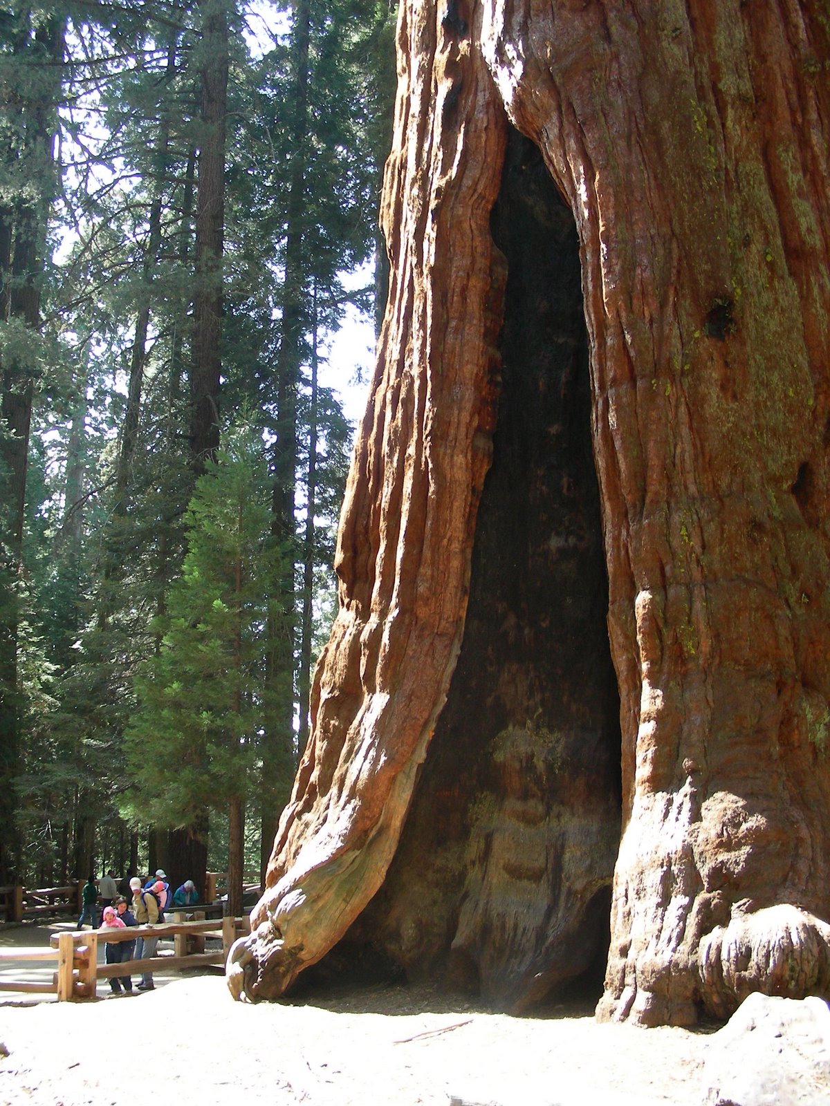
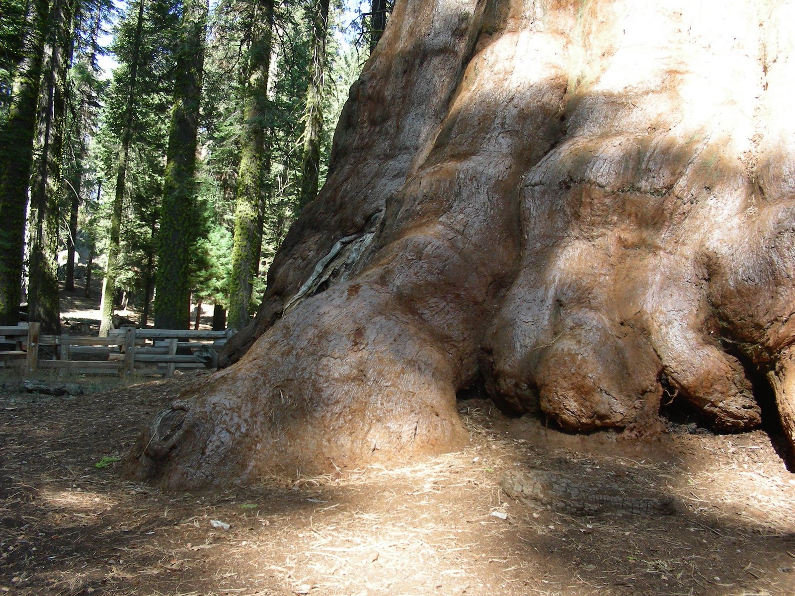
We woke up in Kings Canyon to a very cold morning, but the sunny skies were encouraging after all the predicted rain and snow for the Sierra’s this weekend. We arrived at the boundary of Sequoia National Park in the early afternoon after driving some seriously rough roads throughout the national forest, the national monument, and the national park. Sequoia doesn’t lend itself well to much in the way of sightseeing aside from the major grove that is home to the General Sherman Tree and what is called Giant Grove.


There were several roads that were limited to us because of our length over 22 feet, but we still had time to walk the major groves, see the really big trees, and find a place to camp at the open campground called Lodgepole. It was still cold enough that we needed hats and gloves for hiking, and the warmth of our furnace was really welcome after we got set up for evening.

The campground at Lodgepole is extensive, more so than we realized at first, and there are loops that are by the river, and other loops that say “no generators”, and many delightful places to camp among the granite boulders. Lodgepole has a market and a visitor center that is open year round, although I wouldn’t particularly like driving those rough curvy roads in winter, even if they are plowed!

The store provided a nice bottle of wine and the heater made for a lovely afternoon nap in the sunlight streaming in through the window, and we didn’t need much else to be perfectly content.


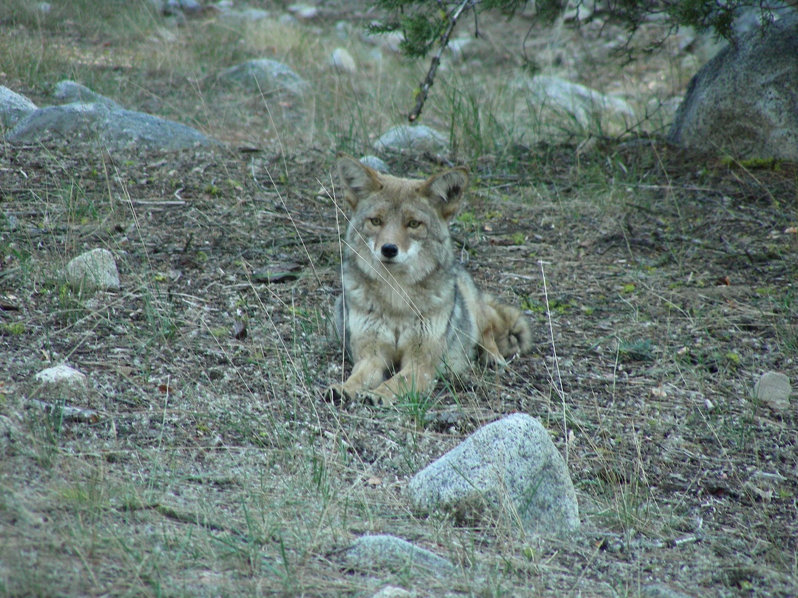
The little coyote (photos at the Picassa link) was our camp mascot, trotting into the camp as we set up, and lying down to see if we were going to leave anything around for him. We saw him several times during our stay, always alone. He really liked Abby, so we kept a close lead on her while he let out playful little growls in his throat, and finally couldn’t help himself and he howled. In spite of his early visit, we never heard coyotes in the night, but Mo was careful to keep Abby on the leash when she went out. After a great bbq supper we went for a little hike in the twilight and found the trail for tomorrow, came back to camp and started the generator and watched a movie. Especially nice because there wasn’t anyone in the campground close enough to be bothered by it. Relaxing!

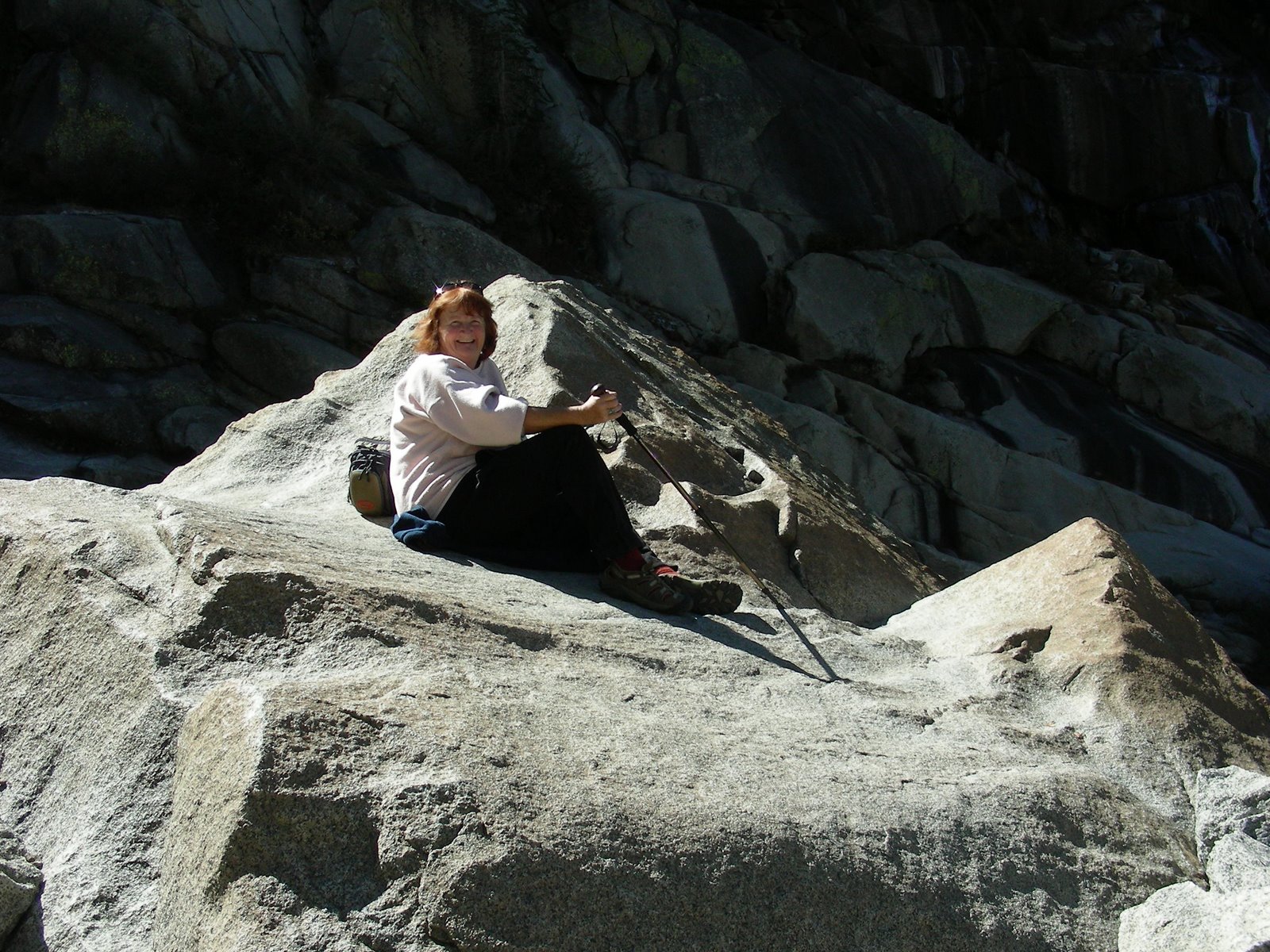
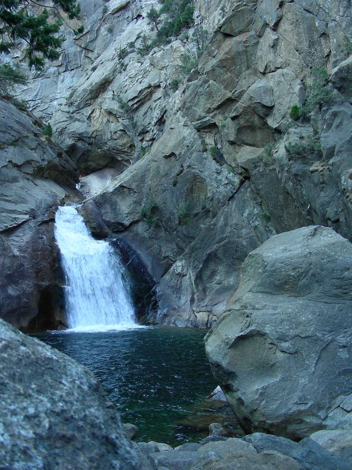
The next morning dawned bright and clear and just a bit warmer after only 28 degrees for the low and we decided that the hike was doable, gloves and hats of course. The hike was lovely, about 3.5 miles round trip and never steep enough to be a problem in spite of the 7200 foot elevation. The rock cascade was dry, with just a trickle of water that was mostly frozen, but it was still nice being there, and you could imagine just how magnificent those falls would be in the spring. Returning to camp we were entertained by a couple of trout playing in the shallows of the crystal clear river under the bridge.

We packed up the rig by noon and headed down the long slide of HWY 180 to the flat valley below, filled with smoke and smog and traffic. I would love to figure out a way to enjoy California without having to cross that valley! As mentioned in the Kings Canyon post, we were really glad that we did this trip this way, since we might not make it this far into this part of California again.

Kings Canyon

http://picasaweb.google.com/kyotesue/KingsCanyon#

Yes, I know the plans were to go to the Bristlecone Pine Forest on the eastern edge of California. One more time, Mother Nature had other plans. There were rumors in the air of bad weather, and sure enough on our expected travel day, we woke to snow falling in the High Sierra and closed passes. Even if we could have made it across HWY 50, the only pass open across the mountains, we would have run into more than 100 miles of 3 inch snow depths on HWY 395 traveling through the Mammoth area. No wayaround it, we had to come up with some other plans for our last trip out this year.

Before we left, the only requirement I had was that we not travel again across the wide, flat, and very boring Central Valley. We decided on a destination that was quite a way down on our to-do list, but was at least accessible, even if cold weather was predicted. With the days of tent camping behind us, cold was do-able. So we headed for the west side of the Sierras instead of the east side as originally planned, and set our sights on Sequoia National Park.

No matter where you travel in this state, however, it’s impossible to avoid the central valley, and we found ourselves headed south on HWY99 one more time into the smog and flatness of Fresno. Once out of town, east on HWY180, we again approached the Sierra Nevada. Only here, very different from my home near Jamestown, the mountains rise very abruptly from the valley floor. HWY 180 is a long steep road climbing 1000 feet every couple of miles until you reach the Kings Canyon National Park entrance at nearly 7000 feet. We were glad we had decided against towing the baby car, also glad that our 26 feet wasn’t any more than that. In fact, at 26 feet, we were too long for several of the national park roads that have a 22 foot limit.

The brochure for these two parks suggests that if you are towing a car with your rig, you should leave the rig and explore by car. The only problem with this plan is that most of the park is only accessible on foot, and what you can see by car isn’t exactly spectacular. The exception to this is the long downhill winding road into Kings Canyon. I would hate to have to drive down that road, and then turn around and drive back out the same day because I didn’t have my home with me. I was also very glad again for the tow-haul on the MoHo that helped with the constant downshifting as we traveled into this wild deep canyon that John Muir compared in all respects to Yosemite.

At the upper limit of the park boundary, however, is a section in the sequoia belt that had some groves of the huge trees, and the General Grant Tree. We stopped to hike the interpretive trails and wonder at these amazing living things before we continued on to our explorations of the park. The ranger was helpful, assuring us that our rig could handle the downhill road into the campgrounds on the Kings River, but also assuring us that we definitely should NOT attempt to go travel on the southern route out of Sequoia to Three Rivers on HWY 198. The maps said, “over 22 feet not advised” not prohibited, but that was a decision for another day.

The trip down the Kings Canyon was a bit obscured that first day by all the clouds in the mountains, and rain and snow falling at varying elevations. The temperature at the top was 37 degrees, and when we reached our campground at 4500 feet or so, it was still in the low 40’s. The night only dropped to 28 degrees at that campground, so again we were happy that we had decided to camp in Kings rather than in Sequoia at a higher elevation where the temperatures dropped to 12 degrees. F. Ahh, camping in October.

Our campground was one of two open on the Kings River, the Sentinal Campground, and when we arrived in mid afternoon was very nearly empty. A couple of people trickled in throughout the evening, and a surprising number of campers were in tents. I didn’t envy them as I watched them curled up in sleeping bags and woolen hats trying to enjoy their campfire, and sometimes there was a funny image of a person huddled over a sterno stove with their partner huddled in the passenger seat of their truck trying to read a book. Cold camping. ugh. We didn’t even opt for a campfire, and instead cooked warm soup and enjoyed the view from our warm cozy home.

The next morning dawned bright and sunny once the sun actually made it over the high mountains, and we traveled further into the park to road’s end and a short hike to the Roaring River Falls before we traveled up that long pull out of the canyon on the way to the next day’s adventures in Sequoia.

We were happy in a way to have been thwarted on our east side Sierra trip, because both of us knew that we might not ever come back in this particular direction and so might not make the effort to see these parks. We also both know that no matter where we live, the eastern Sierra is always calling us, and sooner or later we will find Laurie and Odel’s boondock paradise in the Alabama Hills, and see the Bristlecone Pine Forest. But probably not in October!

Half Moon Bay and the Kings Mountain Art Fair

One of Mo’s friends from her teaching days is a sculptor, and she was showing her wares at an art festival near Half Moon Bay over the Labor Day weekend. See her work here, it’s wonderful! http://www.sharonspencer.com/

It’s always nice to return to the coast, especially since Mo used to live there for so many years. She knows her way around, knows the special little places to find, and enjoys going back for visits. What we hadn’t really considered when we thought of going was that every single camping spot on the entire coast was already spoken for long before Mo started looking around for something to reserve. We decided to go anyway, and take our chances finding a place to park our home. We knew Wal-Marts don’t exist on that part of the coast, but thought maybe we could find a wide place in the road somewhere, or some other kind of creative kind of boondocking opportunity would present itself. It was to be an adventure and we were ready.

We left early Saturday morning, with most of the holiday traffic already landed. We traveled west on 120 toward the 580, the 880, and on to HWY 92 winding over the last range of hills and down to Half Moon Bay. The best part was the gentle fog rolling in over the hills and the dramatic drop in temperatures as we got closer to the ocean. Lovely! The air was so fresh and clean, and when the sun came through it was sparkly and white.

Arriving before noon, we optimistically tried the local state park for cancellations, none of course. We wandered up the coast with other ideas in mind when we saw a large group of RV’s just south of Moss Beach at the Pillar Point Marina. For 30 bucks a night we were privileged to park on asphalt with no amenities other than proximity to the ocean and reasonable safety for us and our rig, not a bad deal really on the coast of California during Labor Day Weekend with no reservations. Later we realized that the place wasn’t policed very strongly, and it would probably be a fine place to boondock for a night on the coast if one didn’t take advantage of it too often, and landed late in the evening and left early in the morning.

We returned each evening to our parking lot haven, and woke this morning to an almost completely empty space, with nothing to obstruct our view of the marina, the fishing boats, and the ocean beyond the breakwater. Reading about the marina was interesting, and it was nice to see a place that was devoted to commercial fishing rather than just fancy boats. You could even buy fresh tuna and halibut right off the pier from the catch of the day. We chose instead to eat our fresh fish at Ketch Joanne’s, a great little restaurant that was another of Mo’s hidden gems from her years in Montara. http://www.ketchjoannerestaurant.com/

http://www.smharbor.com/pillarpoint/index.htm

Once settled in, we spent the rest of the afternoon exploring the tiny sweet town of Half Moon Bay, with its delightful shops. I especially enjoyed Cunha’s Country grocery store, which has been there since the 40’s, with rows of incredible variety in a small store, organic foods, and specially bottled sauces and dressings. Favorite was the Roasted Raspberry Chipotle sauce which we used for a great dinner of bbq’d pork chops and Cream Vidalia Onion Dressing for the salad.

Then there is the feed store.
http://www.halfmoonbayfeedandfuel.com/fnfindex.html

Still in place, right in down town. Walk in off the sidewalk to the smell of hay and grain, chicken feed and chickens even. Huge walls covered with livestock ribbons, saddles and ropes, and all you could need if you had animals. Downtown. It was amazing. Of course, we laughed with all the other people on the sidewalk at the feed store clerk trying to catch an unruly rooster in downtown traffic. I guess he must have escaped the feed store somehow. Mo said that she used to buy all her feed here when she had the ranch back in Montara. It was wonderful to see it still operating and doing so well.

We had a great time walking beaches, and took a side trip to explore the tide pools at the Fitzgerald Reserve
http://www.fitzgeraldreserve.org/

On Sunday we spent the morning at the Kings Mountain Art Fair, a wonderful venue in the redwoods on SkyLine Drive, with booths of paintings, ceramics and sculpture from the finest juried artists around, including Mo’s friend Sharon.

http://www.kingsmountainartfair.com/

We spent Monday relaxing and then drove to all the farms along the highway that are so celebrated for their pumpkin festival in the fall. I found gorgeous flowers at a great nursery and had a great time.

Choosing to leave the coast this morning rather than on the holiday, we are back to Jamestown today after a reasonably easy drive home. Mo will be returning to Klamath tomorrow after our quick little foray to the beach, and we still have a couple of good camping trips waiting for us before the snow flies.

Smoky weekend at Medicine Lake

California was incredibly smoky this weekend. When I left home in Jamestown it was reasonably clear, but by the time I reached the interstate the smoke was thick and only got thicker as I drove north. Here is a photo of what I-5 looked like north of Corning. But I had a goal, and drove through all that smoke for 380 miles to reach this perfect little gem of a lake in northern California, where Mo was already camped with the MoHo.
http://findarticles.com/p/articles/mi_m1216/is_n3_v181/ai_6607000

Even Mt Shasta was invisible to me as I drove the usually magnificent McCloud HWY 89 to Harris Spring Road and the final 33 miles to the lake. Once I was there, and settled in, it was worth it. Mo arrived earlier in the week on Wednesday afternoon, and managed to get a perfect spot right on the lake. Number 45. Each time we have camped here, we have been in the Hogue Campground, along the northern side of the lake, and each time we have managed a lake front site. It gets a bit more challenging with the bigger MoHo, but still at only 25.5 feet, she managed to slide in to this lovely site, and with a bit of additional leveling we had a perfect lake view, room for the awning between the trees, and amazing privacy, even though the campground was more than half full over the weekend. For bigger rigs, there are nice roomy level private sites farther uphill, but the lake view is well worth the juggling. We saw some fairly big rigs in these sites, easy and comfortable.
The best part about Medicine Lake is how uncrowded it is, even on sunny Saturday afternoons. The water is clear, and the lake rules allow speedboats between the hours of 10 and 5, so there are quiet times for kayaks and canoes and everyone is happy. We saw people doing lots of fishing, and one happy person said the fish were fairly easy to catch, they just jump on the hook when you put it out there. It is one of the few places that Mo and I really enjoy returning to when there are so many new places to visit. It’s clean and open and the camp spaces are far enough apart that most of the time it feels private and spacious. We take the boats down to the beach and leave them there for the entire visit, kayaking in the late evenings or early mornings when the winds are quiet. On this trip, there was more wind than usual, even early in the day, so our paddles were a bit restricted, and the air wasn’t as perfectly clear as it usually is, but even so, it was relaxing and a great way to spend a week, or a weekend. We hiked along the lake to the tiny little Medicine Lake and Abby thought the entire trip was just so that she could swim every day and often. Mo brought along plenty of firewood from home as well so we had some truly lovely roaring fires night and morning . Back to Jamestown Sunday evening, and just another week of work and a weekend to get ready for the Spokane trip. I can hardly wait, but in the meantime, the Medicine Lake trip was a wonderful respite from the daily dig.

Posted by Picasa

Medicine Lake Highlands

This is the lovely lake that awaits our next trip, nestled into the Medicine Lake Highlands of northern California. The serenity pictured here belies the rumble beneath the surface that may one day become part of the landscape. Geothermal energy is here, part of the very recent volcanic activity that created some of the magical features in this area, and it’s development is a controversial subject.
http://vulcan.wr.usgs.gov/Volcanoes/MedicineLake/Locale/framework.html

For now, here’s a photo of a quiet evening spent in 2006. I guess the campfire proves I am a true camper, or at least Mo is, since she is usually in charge of the fires. Recently, Laurie of the blog “Semi-True Tales of Our Life on the Road” http://laurieandodel.blogspot.com/ said one of the differences between fulltimers and campers is that fulltimers don’t build fires. Read her very funny story about campfires and mosquitoes and Odel in a sweat shirt at 78 degrees! I have never met either of them, but Laurie’s wonderfully descriptive sharing of their life on the road is a delight and an inspiration to me. I hope to one day be a full-timer as well, and will learn much from all that she has written.