Day 1 in Washington DC Sunday Oct 4

http://picasaweb.google.com/kyotesue/DCDay1#

We decided that Sunday should be a day on our own trying to get the lay of the land and learning how to get around in the city. We scheduled the shuttle provided by the hotel to take us to the Metro station in Ballston. It’s always a bit exciting and fun to figure out the transportation in a new unknown city and this was no different. The Metro is fairly straightforward and we managed our way around on our first day in town without any mishaps. It’s only about 15 minutes from the Ballston station to the Metro Center in the middle of downtown DC. This was fun for me because I have never actually traveled on a subway. Even my forays on the BART in the Bay Area haven’t actually been under the water.

Trying to determine exactly where we were in the city itself was challenging at first. The city isn’t completely oriented on the cardinal directions and my sense of direction is so messed up here that it took days for me to get my bearings. I make maps for a living so I should be a pro! Mo laughed and decided that she should be the one to read directions in the city and leave the country directions to me.

One lesson learned it is a great city for walking and it is BIG. There are large wonderful open spaces that look deceptively short. It is misleading because of all the openness. For instance, from the west end of the Capitol Mall and the Lincoln Memorial to the east end and the Capitol it is about 3 miles. We walked a portion of the mall taking in many of the sites along the way. 
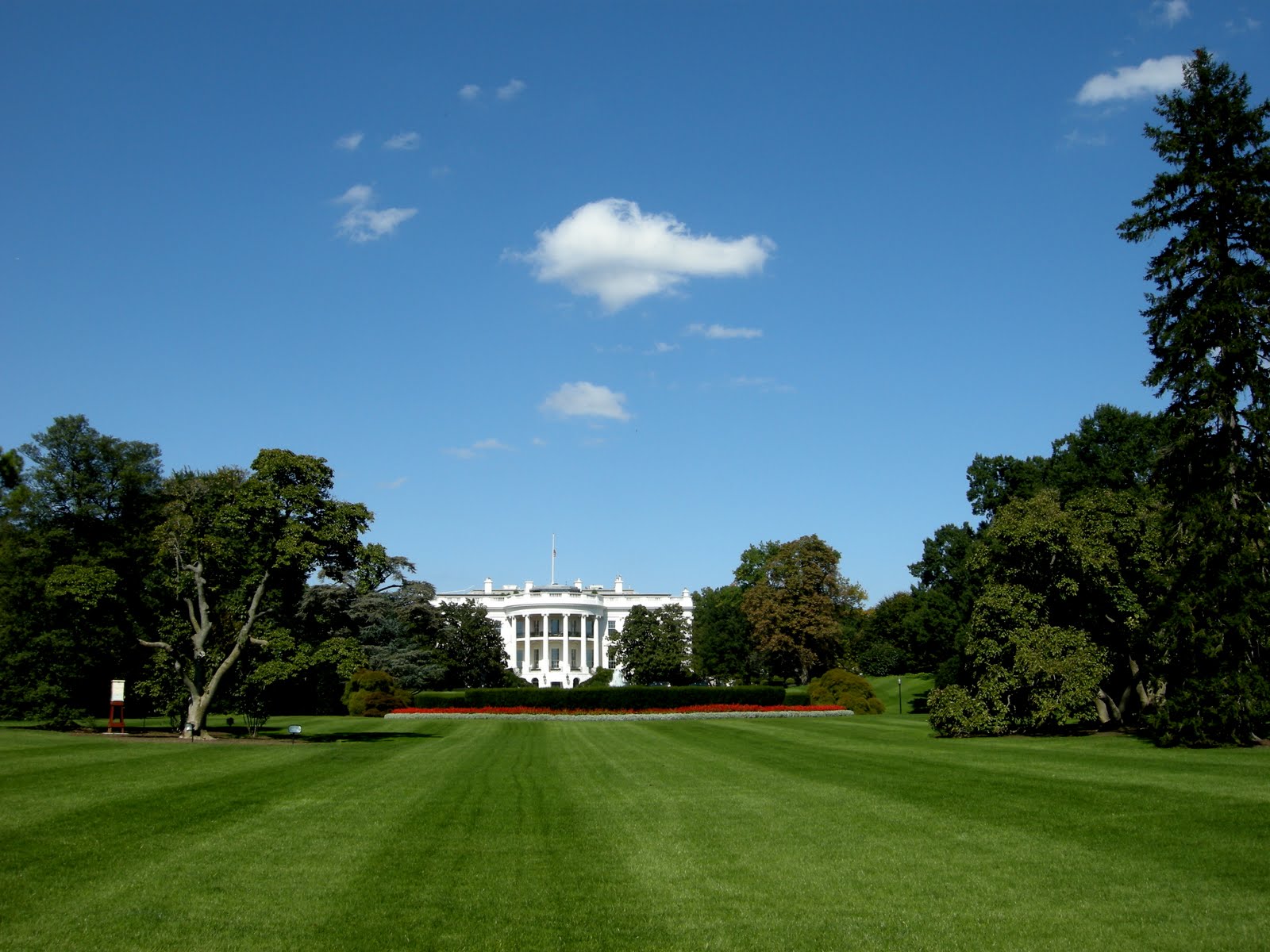
A perfect beginning was the exploration of the Old Post Office. The history of the building is complex and more than once it came close to being torn down. The tower tour is free and offers an excellent view of the city. It was great for our orientation and helped us get a feel for where we were located in relation to the rest of the city. Washington DC was once a swamp and the Potomac River flows to the south and west without many landscape features to use for orientation. From the tower of the Old Post Office, however, we could see in all directions. The National Cathedral is to the northwest on the highest point in the city. We could see all the way down Pennsylvania Street to the Capitol. Dominating the skyline to the south was the Washington Monument. After climbing the steps to see the 10 bells , we headed west to find the White House and see what we could of the Mall.

Most everything here is something that you have seen on TV, read about, or seen in pictures all your lives. It all feels familiar, but it is really bigger than life. in real life. It is inspiring to stand outside the fence to the White House grounds and to hear people speaking many languages. Many seemed in awe while taking photos taking photos. We all took turns at a space along the fence to get a photo of ourselves with the White House in the background.

Later, we walked along the huge grassy fields around the Washington Monument to the World War II Memorial, the reflecting pools and the white marble Lincoln Memorial. As I walked I remembered so many images from the news of protests and gatherings in this place. As our guide said today, this is the place where our freedom of speech is fully expressed. We can gather and protest here and speak our mind in this space. No dogs will attack us, no police with guns will shoot us down. The “I Have a Dream” speech rang out from these steps where I stood dwarfed by the Lincoln statue. It is moving no matter how cynical I might be sometimes about my government.

We walked along the Constitution Gardens passing a lovely pond on the way to the Viet Nam Memorial. I knew about the controversy around this memorial, the ‘black gash in the ground”, but for me it was truly beautiful. Contemplative, reflective, simple and somber. The way it should be. It is very different from the WWII memorial with its sense of pomp and ceremony.

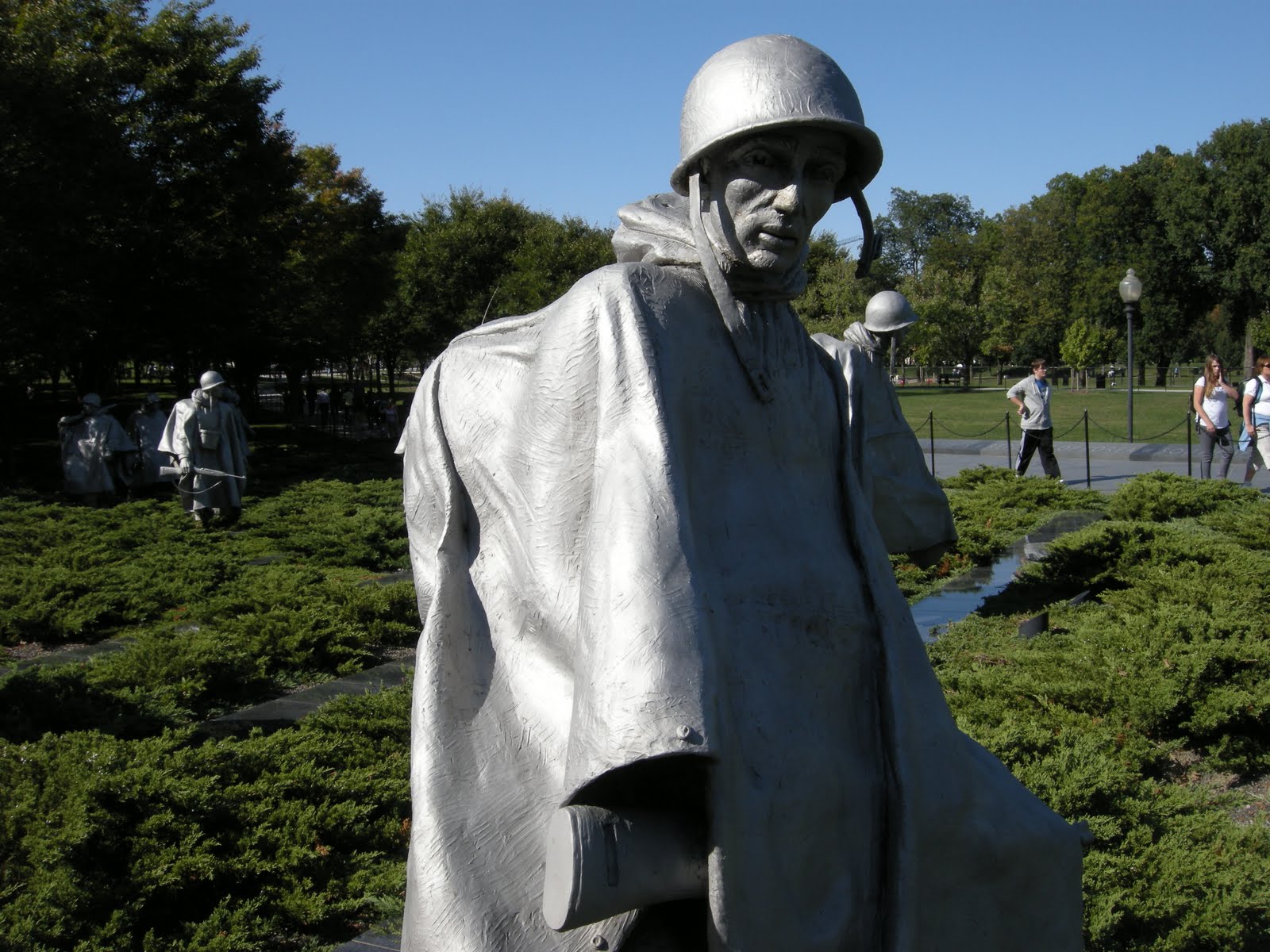
Then, on the opposite side of the reflective pool, we saw the Korean War Memorial. The memorial was only dedicated in 1995, even though the Viet Nam Memorial has been here since 1983. The forgotten war. No wonder people were upset about the lack of a memorial honoring Korean War Veterans. The numbers are staggering. The Korean war lasted only 3 years and more than 40,000 troops were lost and more than a million United Nations troops were injured. In contrast, the Viet Nam war lasted 16 years with a similar number of casualties. No one talked much about the Korean War, and we have never signed a treaty or an armistice. It is a sobering thought.

By the time we headed back west toward the Metro Center we were darned tired and both of us had aching feet and ankles. I think we walked more than 6 miles and were really feeling it. We planned to go on to Ballston for some supper, but on the way to the station we found the Elephant Castle Pub and stopped for good fish, chips and beer. It was a perfect respite before boarding the metro for the trip home. The hotel shuttle is doing a great job of picking us up and dropping us off and the reviews that said they were never on time were just not true. They have been great!

Home to our comfortable room, a good shower, and a great night’s sleep.

Day zero traveling to DC Saturday Oct 3

Although lots of the stories here revolve around the MoHo and RV travel, we do sometimes wander off to see things in other ways. This time it was a trip to Washington DC, a destination too far away to manage a MoHo trip, at least while I am still working and have to deal with limited leave time. Neither of us had been to DC previously, and since my agency developed a great soils exhibit for the Smithsonian, I figured it was as good a time as any to take a week off and go see our Capital City.

We flew from San Francisco on Saturday morning, leaving Jamestown, California at 4am to give ourselves plenty of time to negotiate the bay area traffic. Good thing! There were closed ramps and freeways in the midst of construction somewhere around Hayward that had us going in circles in the dark trying to find a way over the San Mateo Bridge. Never managed that, and ended up going via the Dumbarton Bridge instead to find HWY 101 and still make it to the Travelodge in time for the shuttle to the airport. Whew! We had plenty of time to get checked in and on the plane with no other mishaps.

We have learned that one of the best ways to fly from San Francisco is to stay at the Travelodge in South San Francisco, which has a fly and park package that is very inexpensive compared to parking a car at the airport. The package includes a night on either end of your flights, free parking for 10 days, and a shuttle to the airport both ways. Travelodge Park and Fly

The flight seemed incredibly fast at 4.5 hours direct to Dulles with good weather all the way. On the DC end of the flight we made arrangements with the Super Shuttle. This is an excellent way to travel to and from the airport in DC. Dulles Super Shuttle

Our baggage was on time, the shuttle to Arlington was easy, and the Comfort Inn we had reserved turned out to be more than adequate. After we checked in, dinner was an easy walk across a very big very busy Arlington Blvd to a Chinese place called XO Taste. It was very similar to a Chinese restaurant we once went to in San Francisco, but at least there was also English on the menu. The entire place was filled with Chinese people, not simply Asians, but very much Chinese. We were the only Caucasions in the place. It was a bit embarrassing to be the only ones using forks. After a half-hearted attempt at using chopsticks we gave up and returned to our forks. The dinner was excellent and more than plentiful.

Back home to a good night’s sleep, marred only by a stupid migraine for me. Sigh. Maybe it was the air pressure changes. More than likely, it was the MSG in the really great Chinese food from the previous night. Ah well. It made for a vaguely misfired day for me on Monday, but by evening it was finally gone and now I’m great.

Day 3 Virginia Lakes Hike

Although we planned this east side trip for high desert and seeing Bodie, the Virginia Lakes hike was an unexpected surprise. Chris Savastio, one of my soil survey crew, had been here earlier in the summer and kept insisting that I should see it. We decided to spend our third day on the east side of the mountains exploring these lakes.

I have so many photos of this lovely chain of hanging valley lakes that it’s hard to choose, so just check out the link to see all of it. The hike was just challenging enough to be fun, and I was hoping that I wouldn’t have a problem with the elevation, and think that our two days of camping at 7,000 feet helped a bit. I made it to the 11,100 foot pass without any problems. Abby had her fill of swimming in each lake and some of the highest ponds, the winds weren’t unbearable, and of course, the views from the pass were breathtaking.

The hike was only 6 miles or so, round trip, but we spent most of the day on the trail and were happy to get back home to our camp and the last evening campfire supper. Our last night out before returning home saw the temperature drop to 34 degrees, and in the morning the heater felt very good and the generator was a good thing to have!

Mo took down the solar panel, we buttoned up the MoHo is short order and waved bye to each other as she headed back north to Klamath and I followed the gorgeous Sonora Pass back to Jamestown. Truly a perfect weekend with just a little bit of everything wonderful

Day 2 home to Twin Lakes

After traveling through the desert all day, it was wonderful to return to our private camp, rest a bit, and then take Abby up to the lakes again for a swim. We saw people fishing and walking or biking with great strings of very large trout, so it must be a good fishing lake. There are actually two lakes, with the lower Twin being a bit more private and accessible through the back way along the east side, and the upper lake has steeper banks with the Twin Lakes Resort on the southern end. The water was crystal clear and just a bit chilly, but Abby didn’t mind at all. I only made it in up to my thighs!


Ended the evening with some writing time and a wonderful campfire supper of zuchinni with onions and garlic, a fresh salad, and t-bone steaks, which of course were a hit with Abby as well. Once again, no bugs! Amazing. While I was sitting at the picnic table writing this post, Mo looked up from the fire she was tending and said, “How could anyone ask for anything better than this??” We both decided this was one of the most relaxed and restful sites we have camped in to date.

Just for fun, click here to see a video of Abby enjoying swimming at Twin Lakes.

Day 2 Visiting Bodie


Photos of Bodie are here:

Deciding on an early breakfast of coffee and little powdered sugar baby donuts, we planned an early start for our adventure to Bodie. We gassed up in Bridgeport, at 3.99 per gallon for regular gas, in the midst of motorcycle rallies, a big rodeo, art shows on the courthouse lawn, and general busy-ness. Once we left Bridgeport, however, things quieted down again, even on 395. The road to Bodie from the highway is only 13 miles, 10 of it paved, and was a bit curvy but not a problem at all.

We have often traveled past the HWY 270 sign to Bodie, thinking we should go there, and for one reason or another never made it. Initially we thought we might boondock along this road, after receiving some correspondence from the BLM saying it was ok to do so. But even though there were some possible wide places in the road, it still is much less private and at this time of year we wouldn’t be able to have a fire in the evening, which we can do back at our forest service campground.

Bodie was wonderful, and a bit sad. I first saw this piece of old western history in 1971 when my children were small, and there were no people around then, and no fees. Today it costs 5 bucks per person to enter the park, with an extra 2 bucks for a really nice self guided tour book, well worth the price. We wandered the town with lots of other people, marveling at the history, and the fact that Main Street was once a mile long bordered on both sides by buildings, bars, hotels, and restaurants.

I haven’t included any more photos of the town because they are all so interesting that it is impossible to choose particular photos that really catch the feeling of the place. At one time Bodie boasted 10,000 people and 68 bars. The state of California has managed to preserve things as they were left when the town finally gave up in the 1930’s in a way that doesn’t detract from the originality and mood of what it must have been like to live there. Even so, Bodie is now one of the State Parks of California scheduled to close because of California’s budget woes. It would be a truly sad thing to lose this place to vandals and such because of the state’s management by crisis and focus on so many things of less importance than maintaining some of our history. There is no other ghost town that I know of in the west that is quite like this one.

Rumor was going around that the state also planned to sell off the artifacts on EBay to make money. Reading about the “Bodie Curse” befalling anyone who took even a rock or a plant from the place makes me wonder what would happen to those buying artifacts from Bodie!

We left the busy parking lot and dusty road to return to Bridgeport following the back way through the Bodie hills, with views of the Sierra’s and the desert of Nevada to the west. Found a great little spot near a spring for a picnic lunch, where once more my trusty sleeping bag served us well, providing nice comfort on the hard ground. Abby loved it. We then wound down Aurora Canyon back into Bridgeport.

Tracking another backway, we took the Buckeye road from just west of Bridgeport along the base of the mountains with fabulous views of the Bridgeport Valley. This valley is one of the most extensive wetland valleys I have seen outside of Klamath, and there were literally thousands of cattle grazing on the lush grass.

We got another perspective of the valley by taking the Buckeye road south from 395 into Twin Lakes area. Beautiful! The Buckeye campground is back from this dirt access road another mile or so and can be a bit rough. We probably wouldn’t want to take the MoHo there, but did see some bigger rigs camped, and even some empty spaces available on this Holiday weekend Saturday. In addition, at the crossroads on Buckeye road is the Buckeye spring, which was filled with people the day we passed so we chose not to go there. It is a “clothing optional” spring on the side of the hills above the creek. I plan to check it out someday, but probably not on a weekend!

Backway photos are here: